








200-year-old Red Sea nautical chart unlocks navigation secrets
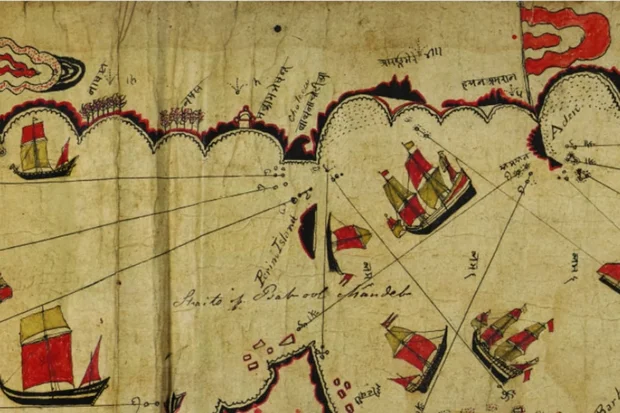
Researchers in the United Kingdom have successfully decoded a 200-year-old nautical chart of the Red Sea, shedding new light on indigenous navigation methods used in the region before the advent of modern maritime technology. Previous attempts to decode the chart in 1947, 1987, 2002, 2012 and 2022 were unsuccessful.
The chart, believed to date from the late 18th or early 19th century, was created by Kachchhi/Gujarati navigators and provides rare insight into seafaring knowledge in the Red Sea and the Gulf of Aden. It has been part of the Royal Geographical Society's collection for nearly two centuries.
Despite predating modern navigational tools, the chart accurately identifies more than 180 islands, reefs and coastal landmarks along the Red Sea. Written in part in Indian languages, including Hindi and Sanskrit, it enabled researchers at the University of Exeter to decode the map using new transcriptions of the Devanagari script, leading to the identification of coordinates for 66 previously unidentified locations.
Prof. John Cooper of the University of Exeter's Institute of Arab and Islamic Studies, who led the study, highlighted the differences between the historic chart and modern cartography.
"Today we are used to maps and charts that project space mathematically and to scale, making regions of the world visually familiar and accessible to us in a very particular way," said Cooper. "Although this chart doesn't look accurate to our way of thinking, it allowed seafarers with the necessary experience and knowledge of stellar navigation to negotiate some of the harshest and most challenging waters in the world."
"All the required information was packed into a very portable scroll just 25 centimeters wide," the researcher explained.
Cooper said the chart served as an effective navigational reference, providing sailors with the astronomical information needed to establish their latitude and sailing direction.
“Its many place names and topographical information enabled them to locate themselves precisely; its religious buildings suggest the navigator's Muslim faith; and its flags suggest nodes of political and fiscal action," he added.
Cooper acknowledged that the chart's effective past use still required navigational knowledge of the region.
“Although rich, the inscribed information would not be enough to enable people uninitiated in regional seafaring traditions to navigate safely,” he said. “But for those who knew, it functioned as a handy reference at sea, fulfilling a mnemonic role. Its scroll format allowed it to be opened partially, showing only the relevant section, with the rest rolled away. It stored and handled easily on board ship."
Dr. Katherine Parker, manager of the Royal Geographical Society's Cartographic Collection, welcomed the discovery and emphasized the value for researchers to revisit historical records and artifacts with modern techniques.
"Re-examining our collections is an ongoing process that allows researchers to apply new methods, technologies and perspectives, uncovering the meanings and utility that these remarkable artefacts held for the people who created them centuries ago," Parker said. We have been delighted to work alongside the team to bring a greater understanding of the navigational, geographical and cultural value of this chart, as well as the cartographic skill and knowledge of its creators, into focus."
Popular article:

interview Easter message of resurrection hope amid war at Jerusalem's Garden Tomb

biblical commentary Let my people go: a Passover message for today

4 IDF soldiers killed, 2 wounded in fighting in southern Lebanon, as Israel eliminates dozens of Hezbollah terrorists

Receive latest news & updates
A message from All Israel News
Help us educate Christians on a daily basis about what is happening in Israel & the Middle East and why it matters.
For as little as $10, you can support ALL ISRAEL NEWS, a non-profit media organization that is supported by readers like you.
Latest articles:

North American Jewish organizations to recruit 100 professionals to combat antisemitism

‘No need’ for pre-election Iran strike, IDF chief says as gov’t, opposition trade blame for potential escalation – report
terror attack 2 Israelis critically wounded, 2 terrorists killed in Hebron shooting; IDF says larger attack was prevented
analysis A people dwelling securely? Israel’s strategic standing, 3 years after Oct 7

Hamas on wheels: What I found in Dearborn reveals a troubling history and a battle over Israel